Authored by: Fabiano Colet, Spyridon Mourtzinis, Tatiane Severo Silva, and Shawn P. Conley
While long-range weather forecasts are always a point of agricultural interest, the growing talk of a “Super” El Niño has taken center stage. This potential climate event is making headlines for its ability to trigger a season of extreme weather across the United States. The latest report, released on May 18, 2026, by the National Oceanic and Atmospheric Administration (NOAA) reported that El Niño is likely to emerge soon (an 82% chance during May-July 2026 and an 98% chance during August-October 2026) and will continue through the Northern Hemisphere winter of 2026-2027. Let’s break down all this information in detail and discuss how that can affect your soybean fields.
What are El Niño and La Niña?
El Niño is a natural, large-scale climate phenomenon marked by warmer-than-average sea-surface temperatures across the central and east-central equatorial Pacific that triggers changes in atmospheric patterns. Differently, La Niña is the opposite of El Niño, characterized by the cooling of the equatorial Pacific sea-surface temperature.
Why can the 2026/27 El Niño become a “Super” or “Very Strong” one?
El Niño conditions develop once the sea surface temperatures rise over 0.5 degrees Celsius above average for an extended period. A “Super” or “Very Strong” phenomenon occurs when water temperatures climb more than 2 degrees Celsius above average. While it is still too early to say definitively whether we will experience a “Super” one, NOAA predicts a nearly 1-in-3 chance (~33% of probability) of a “Very Strong” El Niño, starting in the October-December 2026 period. In addition to that, globally, there is a high probability that this year will be one of the five warmest years on record, and that can be accentuated by the El Niño.
What is the impact of El Niño on Wisconsin’s weather conditions?
No two El Niño events produce identical consequences, making local impacts somewhat unpredictable. Historically, El Niño events during summer and winter manifest differently in the Midwest:
- Summers: El Niño events are usually weaker and have a minor impact on Midwest rainfall and temperature patterns.
- Winters: El Niño typically peaks during this time, impacting the Midwest by producing warmer and drier conditions.
In years with La Niña events, the impact in the Midwest is the opposite during the winter, bringing colder and wetter (snowier) conditions.
El Niño, La Niña, and Soybean Yields: What the Data Shows for Wisconsin
As the planting season progresses and soybean plants emerge to put out their first leaves, farmers are asking, “How will El Niño impact my soybean yields?” The answer to that is not simple, as weather patterns remain unpredictable. However, we analyzed past El Niño, La Niña, and neutral climate events to check how soybean yields responded to these conditions in Wisconsin from 2008 to 2024.
Methods used for data analysis:
Data from the Wisconsin Soybean Variety Trials were analyzed for this study. For each trial location and year, the weather was matched by latitude and longitude, then summarized from planting date to harvest date. Each soybean year was assigned to an El Niño-Southern Oscillation (ENSO) phase (either El Niño, La Niña, or Neutral), using the Oceanic Niño Index, which tracks whether the tropical Pacific Ocean was cooler or warmer than normal.
El Niño and La Niña events were counted only when they lasted at least five overlapping 3-month seasons. For Wisconsin, the spring planting window was represented by March-April-May, while the critical summer reproductive period was represented by June-July-August. Based on these timelines, individual crop years were labeled as full-season, spring-impact, summer-impact, or neutral. Annual yield and weather data were averaged within each individual Wisconsin location first, and then aggregated across all locations to establish statewide averages. The accompanying error bars illustrate the variance among individual location averages within each year.
Let’s discuss how these events have historically affected Wisconsin soybean production:
Wisconsin soybean yield, precipitation, temperature, and weather anomalies by ENSO phase in each year (Figure 1 and Figure 2)
- Yield averages generally increased in more recent years.
- Precipitation moved up and down much more from year to year.
- Temperature changed less than rainfall.
- ENSO phase alone does not explain soybean yield.
- Very dry seasons often lined up with lower yield, but several recent years had good yields even when rainfall was below normal.
- Overall, not only timing and amount of rain matter, but also crop management, genetic improvement, and soil conditions.
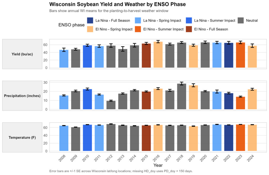
Figure 1. Wisconsin soybean yield (bu/acre) and weather (rainfall and temperature) by ENSO phase from 2008 to 2024.
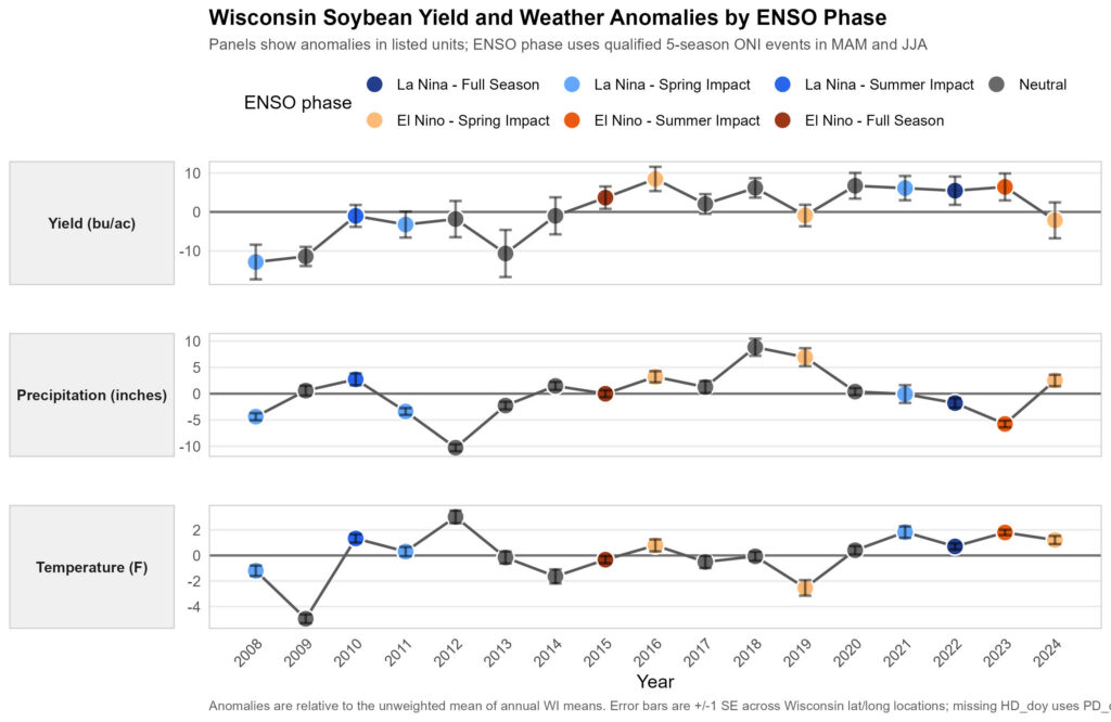
Figure 2. Wisconsin soybean yield difference (bu/acre) between the year-specific average and the 2008-2024 average, and weather (rainfall and temperature) anomalies by ENSO phase from 2008 to 2024.
Were Wisconsin locations wetter or drier than their own normal throughout the years? (Figure 3)
- Locations in 2012 (Neutral), 2013 (Neutral), 2015 (El Niño), 2022 (La Niña), and 2023 (El Niño) were drier than normal.
- Locations in 2010 (La Niña), 2016 (El Niño), 2018 (Neutral), and 2019 (El Niño) were wetter than normal.
- This mixed pattern shows that La Niña or El Niño does not guarantee the same rainfall outcome every time in Wisconsin.
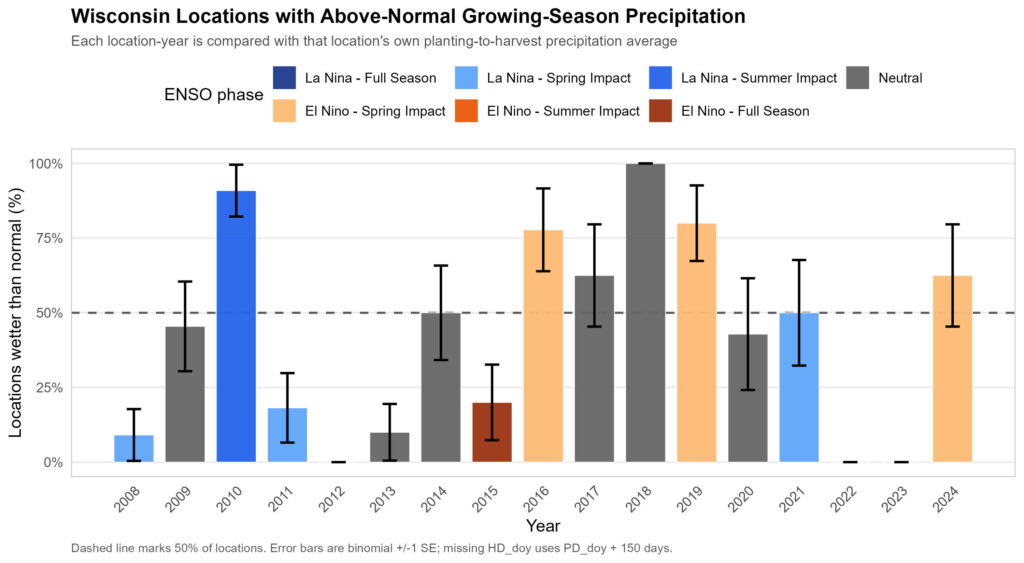
Figure 3. Wisconsin locations with above- or below-normal soybean growing season rainfall from 2008 to 2024.
Yield anomaly vs planting-to-harvest rainfall anomaly (Figure 4)
- While the driest years consistently produce low yields, peak productivity was not guaranteed by rainfall alone; rather, it emerged from the interaction between crop genetics, the local environment, and specific management practices.
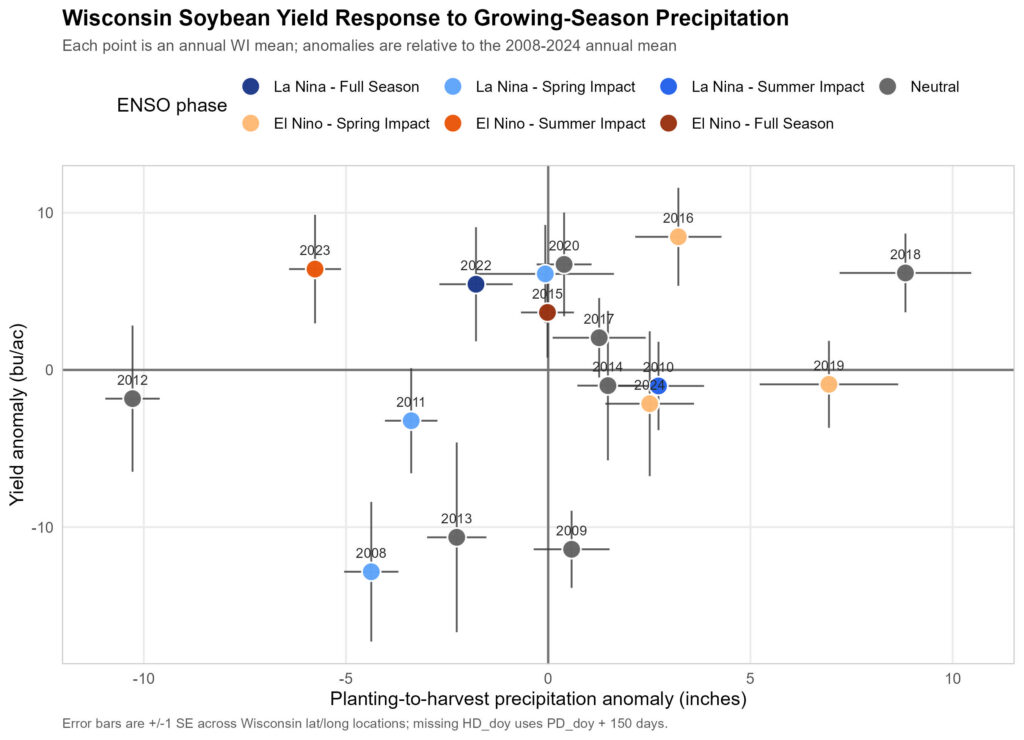
Figure 4. Wisconsin soybean yield response to planting-to-harvest precipitation anomaly from 2008 to 2024.
Anticipated field challenges
Although there is no clear indication that El Niño will cause significant damage to the 2026 WI soybean crop, we are expecting that this will be one of the warmest growing seasons on record. With or without the presence of the Super El Niño, here are some anticipated challenges that farmers may face this year:
- Weed management: If we experience dry and hot temperatures both residual and contact herbicide efficacy may be decreased. There is also a potential increased risk for herbicide carryover.
- Shorter plants: Early-season heat and lack of moisture can result in shorter soybean plants with fewer nodes and reduced overall biomass. With shorter plants, canopy closure can be delayed or may not happen at all, complicating weed management.
- High temperature stressor: Extreme heat during the critical reproductive stages (R1 through R6) can lead to increased flower and pod abortion, and reduction of seed size.
- Insect pressure: Hot, dry weather is the perfect conditions for some pests, such as the two-spotted spider mite.
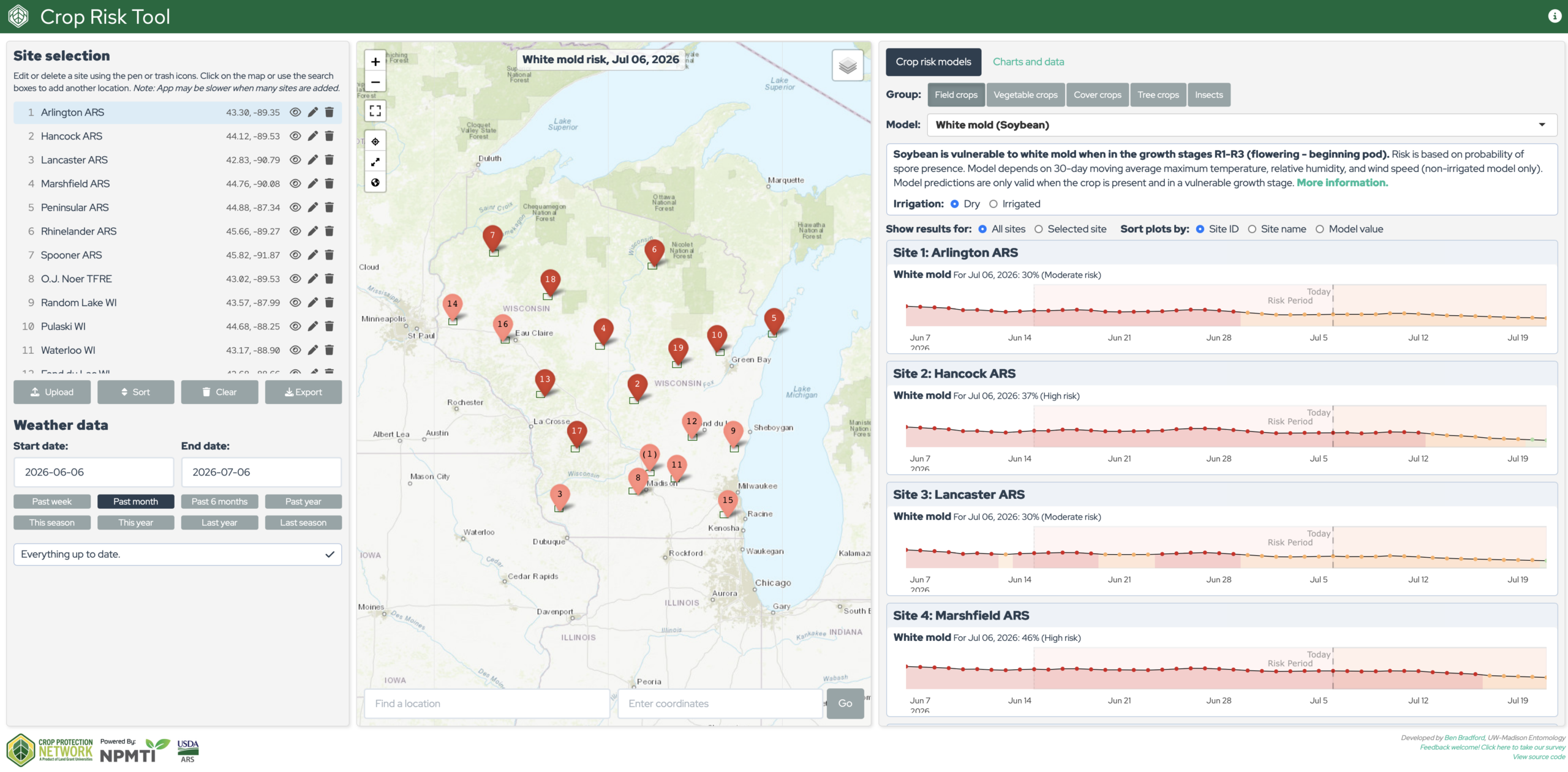
- Disease pressure: Use the CPN Crop Risk Assessment Tool to determine the risk for White Mold or Frog Eye Leaf Spot as in-season weather will drive the severity of these diseases.
- Lower soybean seed yield.
Management strategies
With soybeans already in the ground, growers are facing a difficult combination of high production costs and low market prices. Because a potential El Niño season introduces significant unpredictability, adopting proactive management strategies is essential to mitigating risk and protecting margins.
- Scouting: Step up field scouting schedules for weeds, insects, and diseases.
- Reduction of prophylactic inputs: evaluate the real need for any additional input you were planning to implement in your fields, including foliar fertilizers, foliar biostimulants, fungicide or insecticide applications, sugar and others.
- Have a marketing strategy to reflect the potential impact of a Super El Niño on crop yield.
- Plan for next year: with El Niño still occurring during wintertime, there will be a high probability of dry weather. This can reduce the water table and limit groundwater recharge over winter in Wisconsin. Consequently, the 2027 planting season could have very little subsoil moisture reserves to lean on. Consider adopting management strategies that preserve water in the soil, such as maximizing surface residue (no-till or reduced tillage), reducing soil compaction, and implementing cover crops strategically.
Although there is a 98% probability of an El Niño event, weather remains inherently unpredictable. In Wisconsin, local and regional climate patterns will likely exert more influence over the growing season than global trends. To navigate this uncertainty, producers should prioritize strategies that optimize input efficiency and reduce overall production costs.
References
National Oceanic and Atmospheric Administration. ENSO: Recent Evolution, Current Status and Predictions. Accessed on May 21, 2026. Link.
National Oceanic and Atmospheric Administration. El Niño & La Niña (El Niño-Southern Oscillation). Accessed on May 21, 2026. Link.
National Oceanic and Atmospheric Administration. El Niño and La Niña: Frequently asked questions. Accessed on May 21, 2026. Link.
Midwestern Regional Climate Center. ENSO Impacts. Purdue University. Accessed on May 21, 2026. Link.
Werle, R. 2025 Corn and Soybean Weed Management: Field Observations and Research Updates. University of Wisconsin – Madison. Accessed on May 22, 2026. Link.
Jensen, B. Two-spotted Spider Mites and Dry Weather. University of Wisconsin – Madison. Accessed on May 22, 2026. Link.
NOAA National Centers for Environmental Information, Monthly Global Climate Report for April 2026, published online May 2026, retrieved on May 23, 2026, from https://www.ncei.noaa.gov/access/monitoring/monthly-report/global/202604. DOI: https://www.ncei.noaa.gov/access/metadata/landing-page/bin/iso?id=gov.noaa.ncdc:C00672